Two territories can look identical on a wall map and perform nothing alike. Equal shapes say nothing about the revenue, account load, or drive time packed inside them, and that hidden gap is where most sales plans leak money. Designing territories that actually perform takes software that measures the inside of each boundary, not the outline. They range from free visualization apps to enterprise systems, and only some can do the half of the design that matters, which is acting on what the map shows.
Maptive
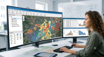
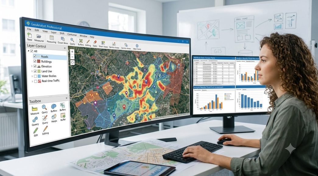
Maptive measures what a high-performing territory needs and a wall map hides. A planner imports accounts, then balances territories by revenue potential or workload rather than raw count, so a patch with 100 enterprise accounts is not treated as equal to one with 100 small ones. The software shows the spread across territories as numbers, so a planner can see where a patch is overloaded well before the quarter starts.
The design tools go beyond drawing boundaries. Heat layers expose where revenue concentrates, drive-time analysis keeps a territory drivable, and a planner can lay several candidate designs over the same accounts and weigh them side by side before any one goes live. When a design fails on screen it costs nothing to fix, while the same failure shipped to the field costs a quarter, so the ability to measure before launch is the feature that matters most.
It earns the lead for any team whose territories have to survive a real quota, the situation where a design that looks balanced but pays unevenly turns into missed numbers and frustrated reps. Measuring the inside of each boundary is the work that prevents that, and that measurement is what Maptive is built around.
Maptitude
Maptitude, from Caliper, is a full mapping and territory package with deep redistricting and alignment tools. It is a favorite for organizations that redraw territories often and want fine control over how boundaries balance, and it carries serious demographic data for market work.
The depth comes with a learning curve and a price aimed at committed users. Assigning thousands of accounts across reps while holding several metrics even is a classic operations research problem, and Maptitude solves it well, but a casual user will feel the weight of all that capability.
CARTO
CARTO is a cloud location-intelligence platform built more for analysts and developers than for a sales manager. It handles large spatial datasets, custom analysis, and integration with data warehouses, which makes it powerful for teams with technical staff.
That power is also its barrier. CARTO assumes comfort with data tools and some coding, so it shines for a data team and overwhelms a sales planner who wants to draw a territory and move on. It is the right answer to a different question than most sales teams are asking.
Tableau
Tableau brings strong visualization with mapping built in, and its free public tier lets anyone plot data geographically at no cost. For seeing where sales concentrate and presenting it cleanly, it is excellent, and many teams already own it for other reporting.
Its limit for territory design is the same as its strength. Tableau visualizes beautifully but does not balance workloads or reassign accounts, so it shows the problem without solving it. It pairs well with a dedicated territory tool rather than replacing one.
Microsoft Power BI
Power BI includes mapping visuals and ships with many Microsoft business subscriptions, so for a lot of companies it is already paid for. It plots regional performance and supports dashboards a whole team can read.
Like other business-intelligence tools, it stops at the picture. Power BI will show a planner that one region holds far more pipeline than its neighbor, but the act of redrawing the boundary to fix it happens somewhere else. It is a fine window onto the data and not a design tool.
Metrics Behind a Strong Territory
Design quality comes down to what a tool can measure, so the metric a planner balances on decides everything else. Account count is the easy choice and the weakest, because a territory with 100 enterprise accounts and one with 100 small accounts are not the same job. Revenue potential balances the actual prize, and workload balances the effort a rep spends to win it. The strongest software lets a planner pick the metric that fits the goal and rebalance against it in a single pass.
Travel is the metric teams forget most often. A territory can balance perfectly on revenue and still waste half the week on the road if its accounts sprawl across a wide region. Software that folds drive time into the balance judges a patch by how long it takes to cover as well as how much it holds. When a tool weighs revenue, workload, and travel together, a planner can see the tension between them and choose deliberately, instead of optimizing one number and finding out about the damage to another only after the territories reach the field. That is the practical meaning of designing for performance rather than appearance.
What Separates a Design Tool from a Viewer
The line that matters runs between software that shows territories and software that builds them. A viewer like Tableau or Power BI surfaces a pattern, and the brain takes in that picture in the blink of an eye where a table would take minutes. That speed of seeing is real value, but seeing is only the first half of design.
The second half is acting on what the map reveals, and using a map to expose a hidden pattern is an old idea. In 1854, John Snow plotted cholera deaths to find a single poisoned pump that a list of addresses never would have shown. A design tool does the same for territories, then lets a planner redraw the lines, which is the step a viewer leaves undone. Drive time belongs in that calculation too, since a balanced patch is worthless if reps spend the week sitting in traffic crossing it. The best software measures, balances, and routes, and the right pick is the one that lets a planner redraw the lines once the pattern shows, a step a viewer never reaches.