
5 Trends in GIS Software Development to Focus on in 2026
Geographic Information Systems have changed a lot during the last decade. What once served mainly as mapping software now supports decision-making in logistics, urban planning, environmental monitoring, agriculture, and infrastructure management.
This article explores the major technological and business trends influencing GIS software development in 2026. See how the role of GIS continues to grow as organizations adopt geospatial data to support operational and strategic decision-making.
AI and ML Integration
AI and ML adoption in GIS software development is shifting from a novelty to a must, especially as data volumes increase. Artificial intelligence and machine learning can analyze and classify spatial data and detect patterns that traditional analysis might miss. With these technologies, business decision-makers can classify satellite images, detect land use changes, identify infrastructure damage, and support predictive analysis. All to help analysts work faster and improve accuracy when working with large datasets.
Mobile-First Solutions
The use of mobile-first GIS applications is growing to support field data collection and on-the-go analysis. A large share of spatial data now comes from field teams who work outside the office and thus, mobile adaptability has become a standard expectation for many GIS systems. Engineers, inspectors, surveyors, and technicians need access to maps and datasets directly on site. Mobile GIS applications allow them to view maps, collect coordinates, update records, and attach photos through smartphones or tablets. All the same functionality, but easy to work with on small screens.
Real-time IoT and Sensor Integration
GIS platforms are expected to integrate location-based data from vehicles, factories, and environmental monitoring stations. Geospatial platforms display this data on interactive maps for use across departments. Logistics teams track shipments, municipalities monitor public transportation systems, and emergency services monitor weather and disaster conditions – all to detect incidents quickly and respond more quickly. GIS software development now includes tools that manage large volumes of sensor data and support instant visualization and alerts.
Focus on Cloud-Native Solutions
The demand is to move from on-premise solutions to cloud-based, subscription-driven platforms that allow to scale without local hardware limitations. Cloud-based solutions allow organizations to expand processing power during high-demand periods and reduce capacity when workloads decrease without hassle, which is especially valuable to industries that depend on seasonal analysis, large satellite datasets, or complex simulations. Moreover, with cloud-ready solutions, companies can store spatial data, run analysis, and simplify data sharing between departments.
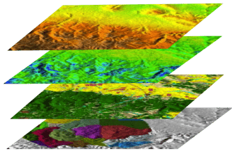
Integration with Drones, Satellites, and Remote Sensing
Remote sensing technologies provide high-resolution spatial data for many industries, including agriculture companies, mining operations, and construction firms. High-resolution satellite imagery, drone photography, and aerial surveys generate detailed datasets that GIS platforms can process and convert into a usable source of geographical data for advanced planning or monitoring.
To summarize, GIS software development in 2026 reflects a clear shift from using GIS as mapping tools into scalable data-driven platforms that support decision-making of organizations across industries. Corsac steps in as a reliable GIS software development partner. Their experts deploy latest GIS software development trends. With Corsacs bespoke experience in GIS software development, organizations can rely on geospatial data to better understand the environments in which they operate and get stronger analytical capabilities.